I recently took a long road trip in California. On the way, I noticed that California’s mile markers look very different than most other states. Let’s take a look. The left image is a typical mile marker, while the right image is a California mile marker.
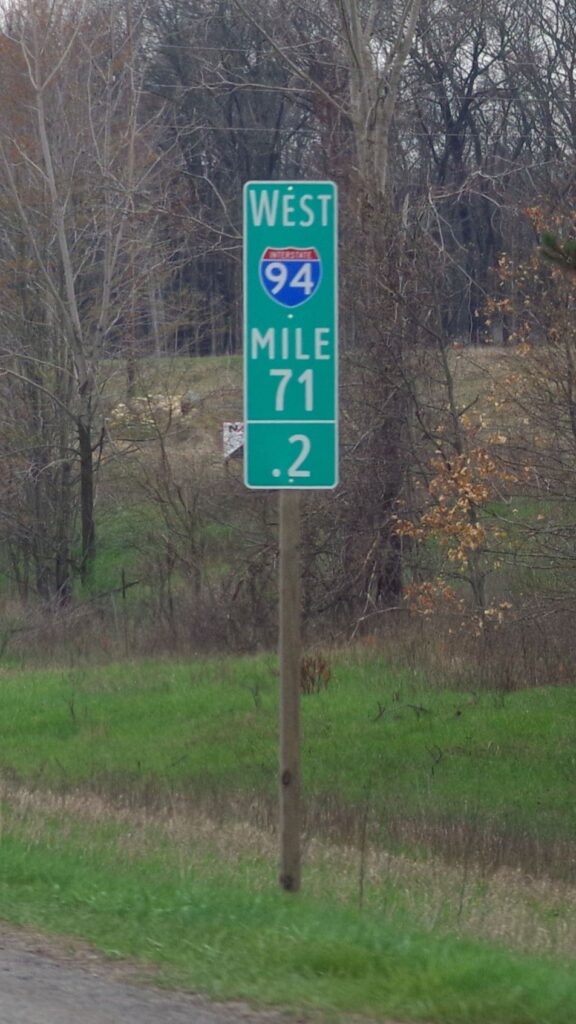
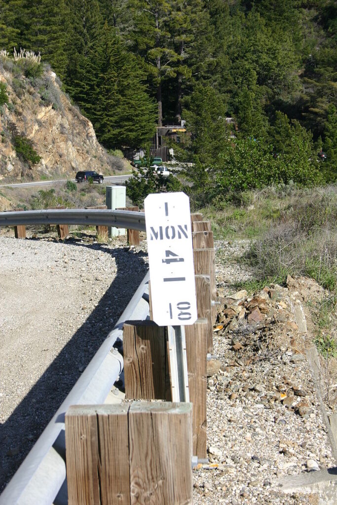
Even on initial glance, the differences between the two mile markers are striking! For example, while the “standard” green mile marker uses the typical MUTCD-specified fonts, California’s mile marker has a white background and a very unusual font. Additionally, the “standard” mile marker is retroreflective and shows a recognizable interstate freeway shield, whereas California’s simply shows the route number at the top of the mile marker (these same white mile markers are deployed to interstates in California, they’re not just on state routes). The frequency of these mile markers also vary. It’s not uncommon to see the green mile markers as frequently as every 0.1 miles. In contrast, California’s mile markers only appear at an interval of one per mile.
The most significant difference between the two mile markers is the actual mile numbering. You may have noticed the three letters “MON” on the California mile marker, which sounds rather reminiscent of the county in which the mile marker appears (Monterey County). It turns out that California mile markers actually reset to zero every time a given road crosses a county line, with one exception I’ll get to later. On the other hand, most other states’ mile markers only reset to zero when a given road crosses a state line; this system is what the MUTCD prescribes. To be blunt, California’s system makes little sense to me. For those unaware of the county-dependent mile numbering system, it could be challenging to communicate one’s location along a highway to emergency services (for example). This issue is made worse by the fact that California’s mile marker signs are not retroreflective, don’t appear that frequently, and have an unintuitive format. However, Caltrans excuses these drawbacks by asserting that mile markers are for government use, not motorist use..,
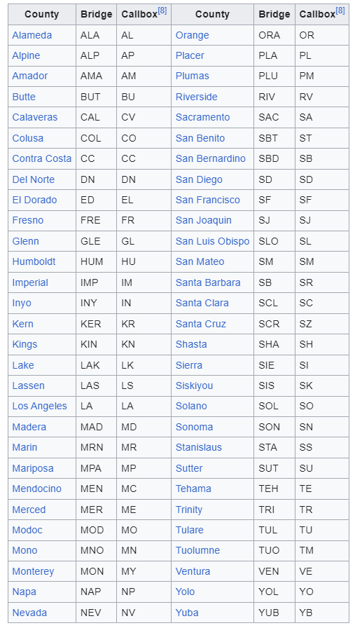
It turns out that California also uses this county-based mile numbering system on the state’s bridge signs. These are white signs that appear at the start and end of almost all state-maintained bridges, and they typically show the bridge name (if applicable) along with the bridge’s location and number. I presume that these signs are useful for Caltrans maintenance workers. Another use case is on the emergency callboxes located sporadically along the side of many roads, especially rural/remote ones. Although the numbering system is the same as on the white mile marker signs, the callboxes use different county abbreviations than the mile markers! Most counties have three-letter county abbreviations on the mile markers, but they all have different two-letter abbreviations on callbox signs. This is the case even though most callboxes already state the full county name at the top of the blue callbox sign. Additionally, there is an existing convention of numbering callboxes on one side of the road with even mile numbers and callboxes on the other side with odd mile numbers – even if two callboxes on opposite sides of a road are directly across from each other.
Wait, there’s more! Not every mile number is made the same. Caltrans defines a wide variety of mile number prefixes, each with a different meaning. For instance, a mile number prefixed with “R” represents a road realignment, “D” represents a duplicate mile number (which can happen if a given road crosses a county line multiple times), “S” represents a spur road, “T” represents a temporary number, and “C” represents parallel truck lanes. If you thought this isn’t crazy enough, there are even more prefixes. A “M” prefix is a realignment of a realignment, and a “N” prefix is a realignment of a realignment of a realignment (yes, I’m being serious). And “H” is a realignment of a duplicate mile number. There are even certain cases of realignment where two mile markers appear, one (marked with “BK”) showing the mileage at that point before the realignment and the other showing the mileage at that point after the realignment (marked with “AT”). How many realignments could we possibly need?
There are even more inconsistencies across this already-inconsistent system. For instance, if you are a LA County driver, you might have noticed that quite a few of the mile markers on LA County roads have a red border at the top. This is a feature that only appears in Los Angeles County. Another strange deviation is in Sonoma County, where the mile numbering system starts at 10.00 instead of 0.00, for some reason. Also, in certain counties, callbox signs show an abbreviation for the road name rather than the county name (e.g., Mullholland Dr. callbox signs in Los Angeles County all begin with MH- rather than LA-). Why these county-specific differences even exist is totally beyond me 🙂
I don’t really know the reason for all these weird idiosyncrasies, but California / Caltrans is notoriously slow to adopt any national roadway standards. This is the case for something as simple as numbering miles on highways, and in fact, Caltrans didn’t even implement mile numbered exits (instead of sequentially-numbered exits) until 2002. This was 30+ years after Federal Highway Administration mandated mile numbered exits.
Indeed, California’s mile markers are so weird that they even have their own Wikipedia page.